Directions
Detailed directions to our exhibition venue are shown below but if you just want to download a copy of the individual documents, please select from…
By Train
The nearest station to the venue is Oxford Road. If possible, buy a ticket to Oxford Road rather than Manchester Piccadilly. If your service is a local one which terminates at Piccadilly, it is quicker to exit the station and walk to the venue rather than catch a connection to Oxford Road. If you are travelling from the south on a service which terminates at Piccadilly, it is easier to change at Stockport for a direct service to Oxford Road (there is less walking between the platforms), but check that your rail ticket is valid.
Many train services which don’t terminate at Piccadilly go on to call at Oxford Road, eg, those operated by East Midlands Trains, Transport for Wales, Transpennine Express and Northern. Some services into Manchester Victoria operated by Transpennine Express continue onwards to call at Oxford Road. Check that your rail ticket is valid. Victoria station is about 1 1/2 miles on foot from the exhibition venue.
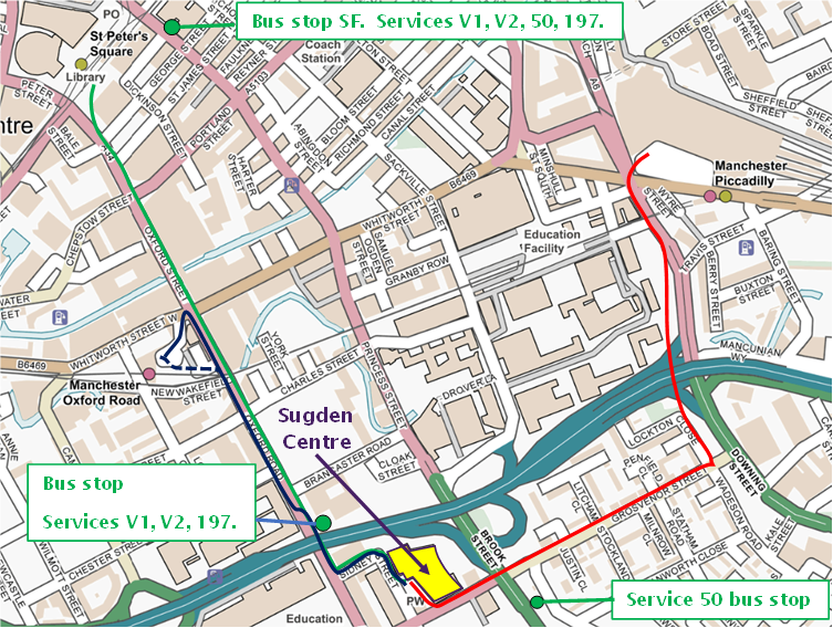
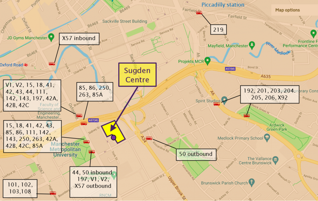
From Oxford Road station to the Sugden Centre (Blue line on map)
Walk down the station approach and bear right at the bottom to reach Oxford Road itself. Turn right on to Oxford Road and pass under the railway. (Note. There is a somewhat shorter route using the long and rather steep stairs on the right hand side of the station approach, shown by a dotted line on the map).
Continue to walk along Oxford Road towards the Mancunian Way flyover just over 200m away. At any convenient point, cross the road to the left hand side.
Shortly after having passed under the Mancunian Way, take the first left turn into Sidney Street. Follow the street as it bends to the right. The entrance to the Sugden Centre is now in front of you.
Total distance: about 670m, or 600m using the steps.
From Victoria station to the Sugden Centre
You can either take the next Transpennine Service to Oxford Road (check your ticket is valid) or use one of the many cross-city bus routes. The Transport for Greater Manchester website has a route planner which will give you several real time alternative routes. https://tfgm.com/plan-a-journey
For anyone not familiar with Manchester, the easiest way is to take a tram to St Peter’s Square and then walk the rest of the way to the venue. The Metrolink tram stop is just outside the ticket barrier for the station. All trams will take you to St Peter’s Square EXCEPT those for Ashton under Lyme or the Etihad Campus.
The route from St Peter’s Square metro stop to the Sugden Centre is shown by the green line on the map below.
On leaving the tram at St Peter’s Square, Oxford Street is to your right and Princess Street to your left when standing with the central library behind you (the big round building with the dome). The distance on foot to the Sugden Centre is about 950m. If you feel that this is too far, then go to Princess Street, cross to the other side, go to bus stop SF and catch any of the services. Ask for “Grosvenor Street” on service 50 and “All Saints” on all the rest. See the map below.
To walk to the exhibition, go down the left hand side of Oxford Street towards the railway viaduct and Mancunian Way flyover which you can see in the distance. Shortly after passing under the Mancunian Way, take the first left turn into Sidney Street. Follow the street as it bends to the right. The entrance to the Sugden Centre is now in front of you.
From Piccadilly station to the Sugden Centre (Red line on map)
If your train terminates at Piccadilly station, follow the signs for the Fairfield Street exit – do NOT exit by the Station Approach. If you have arrived on platforms 1 to 9, turn left as you pass the ticket barrier and take the stairs, escalator or lift to the ground floor to leave the station. The distance to the venue from this point on foot is a shade over 1000m. A black cab from this point should cost about £5.
In front of you is a busy cross-roads controlled by traffic lights. You need to cross to the opposite diagonal corner of this junction – aim for the Bull’s Head public house, leaving it on your right as you walk down London Rd towards the railway viaduct about 50m away.
Pass under the viaduct and continue towards the Mancunian Way flyover. About 40m beyond the railway viaduct there is a pedestrian path and cycle route which diverges to the right. Take this path, which will lead you to a safe crossing point for the very busy road junction where London Road joins with the Mancunian Way.
After crossing the road junction take the right fork in the path which leads you to Lockton Close. Continue in the same direction along Lockton Close for about 80m and then turn right at the crossroads with Grosvenor Street.
Follow Grosvenor Street for just over 300m until you reach the A34, Upper Brook Street. Cross at the traffic light controlled crossing and continue in the same direction for another 90m. This takes you along one side of the Sugden Centre. At the end of the building, turn right. The entrance to the venue is now ahead of you. what3words ///whites.jacket.ranks
NOTE: We Will NOT be operating a shuttle bus between Piccadilly station and the venue.
By Car
Driving into the centre of Manchester can be difficult if you are not familiar with the one-way systems and bus lanes etc. We urge visitors to consider using Transport for Greater Manchester’s Park & Ride scheme which offers a low stress and cost-effective alternative. There are 4 bus park & ride schemes, plus 24 metrolink tram stops and 54 rail stations which offer free parking with a valid travel ticket.
Further details can be found at https://tfgm.com/public-transport/park-and-ride
However, if you decide to drive to the exhibition venue, please remember these TWO very important things:
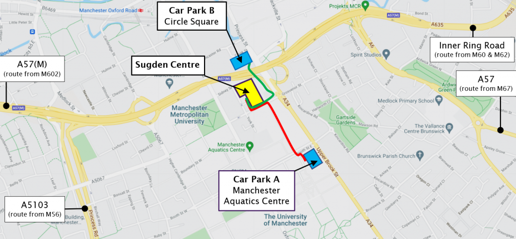
- There is no public car park at the Sugden Centre itself, but there are two multi-storey car parks within 370m of the venue, one significantly cheaper than the other.
- There is a vigorously enforced bus-only scheme on Oxford Road.On no account use the B5117, Oxford Road between its junctions with Hathersage Road and with Charles Street. You WILL be heavily fined.https://www.manchester.gov.uk/info/471/tickets_and_fines/7420/bus_gates/2
If you DO decide to drive into central Manchester, decide which car park you intend to use in advance, because this can have an effect on your best route.
Please refer to the map on the next page for the pedestrian routes from the car parks to the exhibition venue. Since this document was first prepared, the footpath from car park B has deteriorated due to lack of maintenance. We recommend you use car park A (which is also significantly cheaper.)
The venue can be reached from the two carparks as follows:
A – Manchester Aquatics Centre car park, M13 9SS. what3words ///driven.slides.flown
This is the car park we recommend. Distance to venue approx. 370m. Cost £4.50 for up to 4 hours. This is a cashless carpark, only card payments are accepted at the pay stations.
Leave the pedestrian entrance of the car park and turn right. On reaching Brook Street East, cross the road and take Rumford Road which is almost opposite you. Follow this pedestrianised road through the university campus until you reach Grosvenor Street. Cross this road and turn left, walk to the corner of this building and turn right. The entrance to the Sugden Centre is about 30m ahead. what3words ///whites.jacket.ranks
B – Circle Square NCP car park. M1 7ED, what3words ///salads.inch.urgent
https://www.ncp.co.uk/find-a-car-park/car-parks/manchester-circle-square
Distance to venue: approx. 300m. Cost: Between £7.80 – £9.40 for 4 hours depending on payment method. This is a cashless carpark, only card payments are accepted at the pay stations.
Leave the carpark by the pedestrian exit, which is near the vehicle entrance (on the right-hand side when facing towards the road outside). Follow the footpath as it curves under the Mancunian Way until you reach the crossroads of Upper Brook Street and Grosvenor Street, where you should turn right into Grosvenor Street and walk for about 90m. This will take you along the side of the Sugden Centre. At the end of the building turn right and the entrance is about 30m in front of you. what3words ///whites.jacket.ranks
Travelling to Manchester from the South and from Wales
If you are coming from the south, or from Wales, you probably used the M56 for the final section of your journey. As you approach the city, at junction 3 of the M56, follow the signs for the city centre and the A5103, Princess Parkway.
Similarly, if you are coming from the Macclesfield or Congleton direction and used the clockwise M60, leave the M60 at junction 5 and take the A5103, Princess Parkway towards the city centre.
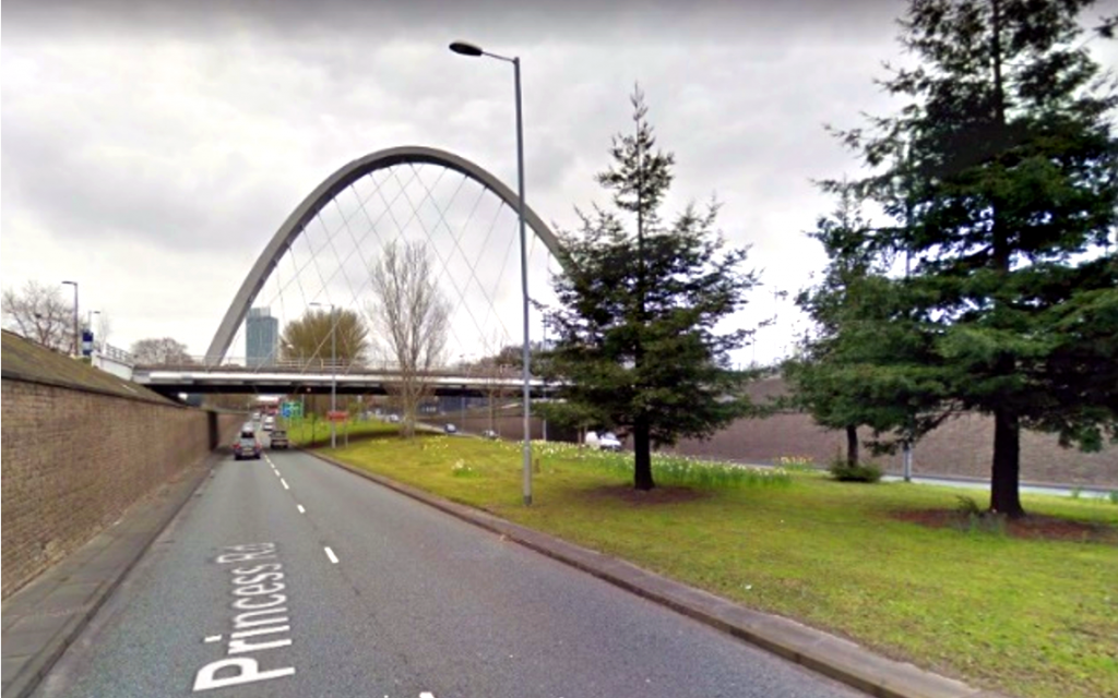 Follow this road for almost 3 miles to its final roundabout. You’ll know you’re near it when you pass under the very distinctive Hulme Arch. You should follow the signs for Ashton-under-Lyne, Sheffield, Piccadilly and Universities.
The roundabout has recently been re-modelled, but turn right and then get in the right hand lane. You will now be travelling parallel to, and underneath, the eastbound A57(M).
At the next roundabout go straight ahead and join the A57(M) Mancunian Way, but you will only be on it for about 350m. As you reach the top of the entry slip road, you will see a square building with large circles in its walls -this is Car Park B: Circle Square.
Just beyond it are two exit slip roads. For Circle Square, take the first, very sharp exit, and the left fork which immediately follows it (signposted A34, Wilmslow & Universities). Car Park B will be directly ahead of you at the next, traffic light controlled, junction.
For Car Park A – Manchester Aquatics Centre (which is cheaper), take the second, more normal, of the two combined slip roads, (signposted A6, Stockport), and get into the right hand lane. At the exit traffic lights, turn right, go under the Mancunian Way and about 120m later turn right again at the next traffic lights, into Grosvenor Street. NOTE: This street is one-way for vehicles but two-way for cyclists!
Follow this road for about 300m until, about 60m before the next traffic lights, turn left into Kincardine Road. (There is a very small amount of on street parking in this road.) After 200m turn right at a mini roundabout into Inchley Road. At the next set of lights, go straight on and about 50m after this, turn left. The Manchester Aquatics Centre Car Park will now be on your left.
Travelling to Manchester from Liverpool, the West and North-West
Consider using the Park & Ride scheme from Wardley on the A580. The V1 & V2 buses use a dedicated busway for most of their journey & stop less than 150m from the venue’s entrance. https://tfgm.com/public-transport/park-and-ride/wardley-bus
If you arrived in Manchester from Liverpool (via the M62) or from Preston or Bolton (via the M61 and anticlockwise M60), you will use the M602 to enter the city. Take this motorway to its end and continue straight on, following the signs for the city centre. This is the A57,Regent Road. Follow this road for about 1.5 miles, following the signs for Sheffield and Universities, until, just underneath some large railway bridges, it becomes the A57(M) Mancunian Way. You will need the combined second and third exit from this motorway.
As you approach the first exit, you will see ahead on the left, a square building with large circles in its walls -this is Car Park B – Circle Square. Just beyond it are two exit slip roads. For Car Park B take the first, very sharp exit, and the left fork which immediately follows it (signposted A34, Wilmslow and Universities). Car Park B will be directly ahead of you at the next, traffic light controlled, junction.
For Car Park A – Manchester Aquatics Centre (which is cheaper), take the second, more normal, of the two combined slip roads, (signposted A6, Stockport), and get into the right hand lane. At the exit traffic lights, turn right, go under the Mancunian Way and about 120m later turn right again at the next traffic lights, into Grosvenor Street. NOTE: This street is one-way for vehicles but two-way for cyclists!
Follow this road for about 300m until, about 60m before the next traffic lights, turn left into Kincardine Road. (There is a very small amount of on street parking in this road.) After 200m turn right at a mini roundabout into Inchley Road. At the next set of lights, go straight on and about 50m after this, turn left. The Manchester Aquatics Centre Car Park will now be on your left.
Travelling to Manchester from the North, Yorkshire and the East
If you’re travelling to Manchester from across the Pennines using the M62 or from the Burnley area via the M66, your route will bring you to the M60 outer ring road. There are a variety of routes from the M60 into the city available to you. Eg junction 17 (A56), junction 19 (A 576), junction 20 (A664), junction 21 (A663) or junction 22 (A62). All of these routes will eventually lead you to the inner ring road, A665, which later becomes the A635. It’s worth checking if there is an event at the Etihad stadium – Manchester City’s ground, since this can cause disruption on some of these routes.
Once on the inner ring road, continue until it becomes the A635, and go on until you reach the junction with the A6. At this point the inner ring road becomes the Mancunian Way, A57(M), but you should fork left on to the A6, then barely 100m later, turn right at the traffic lights into Grosvenor Street (which is a one-way street for cars, but two-way for cyclists!).
To reach Car Park B continue to the next traffic lights and turn right on to Brook Street. Pass under the Mancunian Way and turn left into the carpark about 50m later.
To reach Car Park A (which is cheaper), turn left into Kincardine Road about 60m before the traffic lights on Grosvenor Street. (There is a limited amount of on-street parking on this road.) After 200m, at the mini-roundabout, turn right into Inchey Road and, at the next traffic lights, go straight on, across Upper Brook Street. Take the first left turn and then left again into the carpark.
Travelling to Manchester via the Snake or Woodhead Passes
Towards the end of your journey from South Yorkshire or Derbyshire you will take the M67. At the final junction of this motorway, carry straight on to the A57. This is a fairly straight road which you follow for almost 4 miles until you reach a roundabout. The roundabout has five exits and you need to take the second one, Brunswick Street, which is signposted to Manchester Aquatics Centre.
Follow this road to the junction with the A34 and turn right – again following the signs for the Manchester Aquatics Centre. After about 300m turn left and then left again into Car Park A – the Manchester Aquatics Centre car park.
To reach Car Park B, continue along the A34 for about 400m. The entrance to the car park is on the left just after the Mancunian Way overpass.
By Bus
By Tram